Introduction
See Spanish version here.
Along my bi-weekly commute between Calgary and my job at a mining project in Elkford, British Columbia, on highway #3, I used to drive across the “Crowsnest Pass.” This road traverses the Rocky Mountains and the Continental Divide near the border between Alberta and British Columbia.

Heading west, not far after the hamlet of Bellevue, our eyesight is immediately drawn into the dry and rocky landscape roadsides. At first, it seems like an apocalyptic scene or from another planet.
The grayish tones of the monoliths contrast with the yellow-green landscape during the spring and summer

and with white in the winter.
Crowsnest Pass Mountains
Along the way you can see several peaks and mountains such as: Crowsnest Peak (from which this region takes its name),

Ptolemy (the highest in the region), Tecumseh *, Phillips Peak, and many more, there are about 30.
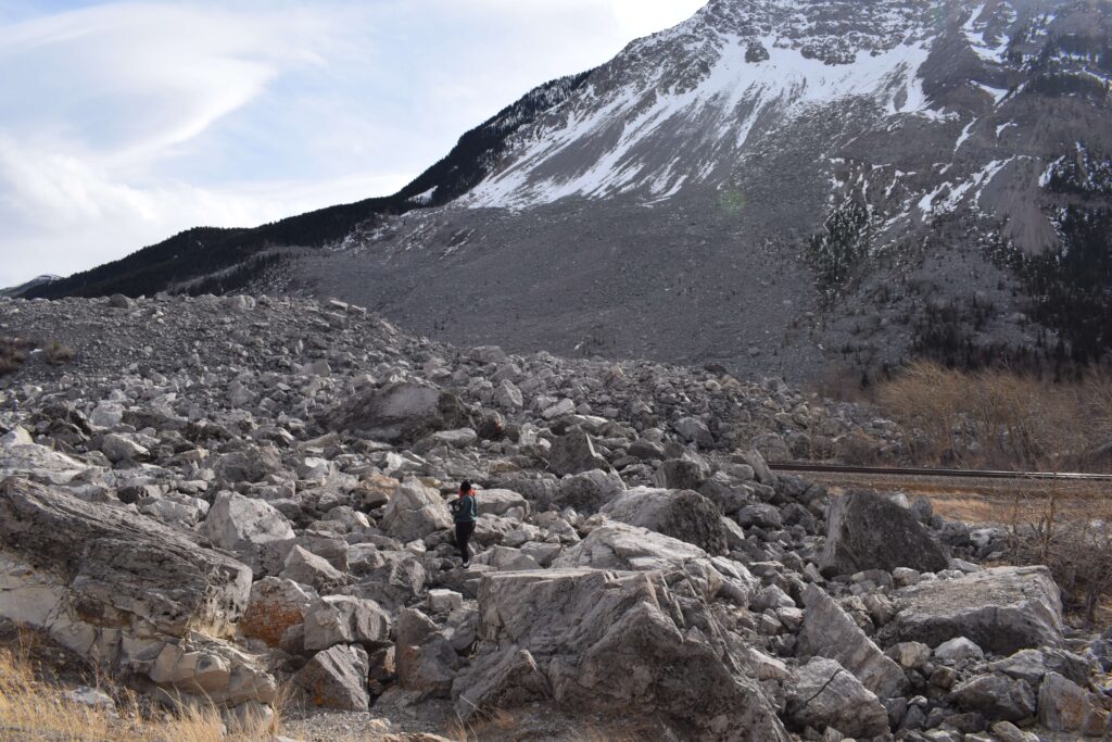
One of these mountains is “Turtle Mountain”, associated with the largest deadly rockslide catastrophe in Canada: Frank Slide.
The town of Frank
At the beginning of the 19th century, the coal boom attracted people from everywhere; new settlements were born. The village of Frank was founded by a mining businessman named Henry Frank in 1901, less than two years before the tragedy.

While the town slept
It was early morning on April 29, 1903, and most of the nearly 600 residents of Frank’s mining community were sleeping.
Night shift men worked on the mine buildings at the coal mine. Then, at 4:01 a.m., a sudden thunderous roar shook all Crowsnest Pass.
A block of limestone more than a kilometer wide, 425 meters long, and 150 meters deep had broken off the top of Turtle Mountain: the mountain “moved”, as an old legend had predicted.

On its shattering travel way down, it dragged other stones of different sizes, causing an avalanche of rocks that rolled and bounced down the mountainside and spread into the valley.
According to calculations, about 100 million tons fell from the mountain, burying a large part of the town in less than 90 seconds and killing more than 90 people.
Debris blocked the entrance to the mine and swept away the mine buildings and those who worked in them. However, the underground miners did survive by tunneling to the surface.

According to testimonies, the avalanche was so thunderous that it created a dense electric dust cloud that poured lightning bolts over the area.
A construction camp, stables and ranches, were all engulfed by rocks. The noise was of such magnitude that it was heard miles away, and clouds of limestone dust hung over the region for months. While everyday life gradually returned to Frank, the tragedy always remained with the townspeople:
“the landslide is always with us”
Aftermath of Frank Slide
Although initially, many attributed mining activities as the cause of the cracking of the mountain, over time, scientific studies have confirmed that the mountain has always had an unstable geological structure.
For the Blackfoot and Ktunaxa indigenous groups, ancestral inhabitants of the region, this mountain has always been a source of fear and mistrust. Oral histories of generations called it the “mountain that moves”, and they always avoided camping on its base.

The place was declared a historic site on August 30, 1977 to raise awareness about the power of nature and human heroism in the face of tragedy. A few years later, in 1985, the initiative to build the interpretive center followed up, which today serves as a source of information about Frank Slide and the history of the Crowsnest Pass region.
The last surviving person in the tragedy died in 1995.

The interpretive center
To reach the interpretive center from the east (Calgary) on highway # 3, follow the Frank Slide luminous sign just before Fas Gas to turn right to 153 St road.

The interpretive center displays informative screens about the tragedy, relics, and artifacts recovered during the rescues, such as shoes, a bed frame, and personal objects.
The audiovisual room on the second-floor projects short films about some of the workers and families, victims of the tragedy. Several testimonies from the survivors and story recreations, such as that of Lilia Clark, the only survivor of her family of four. Matters of fate, that night Lilia had to work night-shift as a maid in the hotel on the other side of town without knowing that that night would be the last farewell to his family.

Images of victims, Clark family on the right image
Surveilling the Mountain
Another of the interpretive center rooms shows the current research and surveilance on the mountain. According to studies, an area under the third peak has the highest probability of landslide on the south side. Two large cracks would cause a torrent of 2.2 million cubic meters of stone.

You can see equipment and photos of the sensors installed at specific points on the mountain connected to high-sensitivity instruments such as the crackmeter to measure the slightest displacements in the cracks and the tiltmeter to measure their level of inclination.

There are also geological-geographical models of the area and information on the Hillcrest catastrophe, the worst tragedy in a mine in Canada, but I will talk about this in a future blog.
Black Beauty
Although not necessarily related to the theme of the rockslide, a 65 million-year-old skull of a Tyrannosaurus Rex called “Black Beauty” is on display. The dark pigmentation on the fossil is due to the level of manganese accumulated in the groundwater during the fossilization process..

The specimen was found in 1980 on the banks of the Crowsnest River by chance, not far from the interpretive center. Three teenagers went fishing in the Crowsnest River, needing better fishing that day; they circumstantially came across some black fossils on the river banks. After reporting their discovery, an archeological excavation followed, resulting in the unearthing of the T Rex skull.
The town of Coleman
I used to drive along this area back and forth between Calgary and Elkford, and I had the chance to appreciate the landscapes in the different seasons of the year. Crowsnest Pass Township comprises several villages and communities, the largest being Coleman and Blairmore, where I occasionally stopped for lunch or dinner.

In the “Rum Runner,” I ordered a sinister burger accompanied by an Alexander Keith.
The place’s name refers to the era of alcohol smuggling that characterized this area during the dry law era in the 1920s.

Crowsnest Pass Museum and the Alberta Provincial Barracks showroom in Coleman are full of more history of the region.

*Tecumseh: indigenous hero of the Shawnee tribe who in 1812 fought against the Americans in the War of 1812, I’ve just discovered this while living in Eastern Canada.
I welcome your feedback, comments, likes and or share on my fb page.
If you found this post interesting, please consider sharing it with others, or you can follow my FB page or instagram.
I invite you to read the one I published a couple months ago: “Murals in Antofagasta” in Chile.
Thank you and have a good day!
EO
